
Gi en donasjon
Topografisk kart Wuhai
Klikk på kartet for å vise høyde.
Gi en donasjon
Om dette kartet
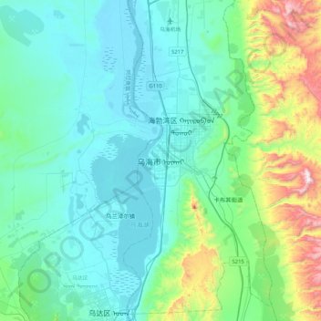
Navn: Topografisk kort Wuhai, højde, relief.
Gjennomsnittlig høyde: 1 252 m
Minste høyde: 1 062 m
Maksimal høyde: 2 147 m
Gi en donasjon
Andre topografiske kart
Klikk på et kart for å se dets topografi, dets høyde og dets relieff.
Xilinhot City
The elevation of Xilinhot is approximately 990 m (3,250 ft). The city is 610 and 620 km (380 and 390 mi) from Beijing and Hohhot (the capital of Inner Mongolia), respectively.
Gjennomsnittlig høyde: 1 162 m
Gi en donasjon
Wuhai City
Wuhai is situated in western Inner Mongolia, in the upper reaches of the Yellow River, which flows through the city. The western bank of the river is Wuda District, while the eastern bank includes Haibowan District and Hainan District. The city borders Ordos City in Inner Mongolia to the east and north,…
Gjennomsnittlig høyde: 1 326 m
Gi en donasjon
Gi en donasjon
Gi en donasjon
Gi en donasjon
Gi en donasjon
Gi en donasjon
Hailar District
Hailar is located in close proximity to the Greater Xing'an Mountains, and has an elevation ranging from 603.0 to 776.6 m (1,978.3 to 2,547.9 ft). Of the city's 1,319.8 square kilometers, 28 square kilometers (or 2.12%) of the district is urban.
Gjennomsnittlig høyde: 670 m
Gi en donasjon
Tongliao City
Tongliao's topography primarily consists of plains, though the northern stretch of the prefecture extends into the eastern foothills of the southern Greater Khingan. The central and eastern parts of the prefecture are marked by the plains of the Xiliao, Xinkai River (新开河), and Jiaolai rivers (教来河),…
Gjennomsnittlig høyde: 262 m
Gi en donasjon
Gi en donasjon
Dorbod Banner
China > Inner Mongolia > Ulanqab City
The banner is located along the northern foothills of the Yin Mountains, and has an average elevation of 1,400 metres (4,600 ft).[3] Most of the banner's area is grassland.[3]
Gjennomsnittlig høyde: 1 294 m
Gi en donasjon