
Gi en donasjon
Topografisk kart McHenry
Klikk på kartet for å vise høyde.
Gi en donasjon
Om dette kartet
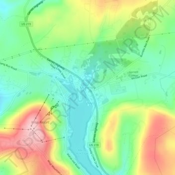
Navn: Topografisk kort McHenry, højde, relief.
Sted: McHenry, Garrett County, Maryland, 21541, United States (39.53842 -79.37282 39.57842 -79.33282)
Gjennomsnittlig høyde: 817 m
Minste høyde: 738 m
Maksimal høyde: 943 m
Gi en donasjon
Andre topografiske kart
Klikk på et kart for å se dets topografi, dets høyde og dets relieff.
Oakland
United States > Maryland > Garrett County
Oakland, owing to its high elevation and valley location, is among the coldest and snowiest locales in the state of Maryland, and has a warm-summer humid continental climate (Köppen Dfb). The state record low of −40 °F or −40 °C was recorded here on January 13, 1912. The monthly mean temperature ranges…
Gjennomsnittlig høyde: 763 m
Gi en donasjon
Gi en donasjon
Savage River State Forest
United States > Maryland > Garrett County > Grantsville
Gjennomsnittlig høyde: 738 m