
Takk for at du støtter denne siden ❤️
Gi en donasjon
Gi en donasjon
Topografisk kart Glen Arbor
Klikk på kartet for å vise høyde.
Takk for at du støtter denne siden ❤️
Gi en donasjon
Gi en donasjon
Om dette kartet
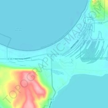
Navn: Topografisk kort Glen Arbor, højde, relief.
Gjennomsnittlig høyde: 194 m
Minste høyde: 172 m
Maksimal høyde: 311 m
Takk for at du støtter denne siden ❤️
Gi en donasjon
Gi en donasjon
Andre topografiske kart
Klikk på et kart for å se dets topografi, dets høyde og dets relieff.
Leelanau State Park
United States > Michigan > Leelanau County > Northport
Gjennomsnittlig høyde: 183 m
Takk for at du støtter denne siden ❤️
Gi en donasjon
Gi en donasjon
Takk for at du støtter denne siden ❤️
Gi en donasjon
Gi en donasjon
South Fox Island
United States > Michigan > Leelanau County
North Fox Island has an operational public 3,001-foot-long by 100-foot-wide (914m x 30m) grass airstrip as of August 2023, making it accessible by general aviation. Runway 7 has a displaced threshold of 804 ft. and Runway 25 has a displaced threshold of 999 ft. Both runways have trees at their ends ranging…
Gjennomsnittlig høyde: 185 m
Takk for at du støtter denne siden ❤️
Gi en donasjon
Gi en donasjon
Sleeping Bear Dunes National Lakeshore
United States > Michigan > Leelanau County
Gjennomsnittlig høyde: 204 m