
Takk for at du støtter denne siden ❤️
Gi en donasjon
Gi en donasjon
Topografisk kart Mount Arvon
Klikk på kartet for å vise høyde.
Takk for at du støtter denne siden ❤️
Gi en donasjon
Gi en donasjon
Mount Arvon
Mount Arvon, elevation 1,979 feet (603 m), is the highest natural point in the U.S. state of Michigan. Located in L'Anse Township, Baraga County, Mount Arvon is part of the Huron Mountains. It rises about eight miles (13 km) south of Lake Superior (elevation 591 feet [180 m]). On the list of highest natural points in each U.S. state, Mount Arvon ranks 38th. It is the highest natural point in the East North Central states.
Takk for at du støtter denne siden ❤️
Gi en donasjon
Gi en donasjon
Om dette kartet
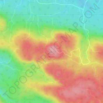
Navn: Topografisk kort Mount Arvon, højde, relief.
Gjennomsnittlig høyde: 526 m
Minste høyde: 455 m
Maksimal høyde: 600 m
Takk for at du støtter denne siden ❤️
Gi en donasjon
Gi en donasjon
Andre topografiske kart
Klikk på et kart for å se dets topografi, dets høyde og dets relieff.