
Gi en donasjon
Topografisk kart Inglis
Klikk på kartet for å vise høyde.
Gi en donasjon
Om dette kartet
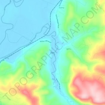
Navn: Topografisk kort Inglis, højde, relief.
Sted: Inglis, Columbia County, Oregon, United States (46.10650 -123.18512 46.14650 -123.14512)
Gjennomsnittlig høyde: 76 m
Minste høyde: -3 m
Maksimal høyde: 252 m
Gi en donasjon
Andre topografiske kart
Klikk på et kart for å se dets topografi, dets høyde og dets relieff.
Vernonia
United States > Oregon > Columbia County
The city has been severely impacted by floods on multiple occasions. The rains that caused the Willamette Valley Flood of 1996 flooded Vernonia as well; some homes in the floodplain were elevated, and some flooring materials were replaced, mitigating some damage from later flooding. In 2007, heavy storms that…
Gjennomsnittlig høyde: 218 m
Gi en donasjon