
Gi en donasjon
Topografisk kart Mexico City
Klikk på kartet for å vise høyde.
Gi en donasjon
Mexico City
Mexico City is located in the Valley of Mexico, sometimes called the Basin of Mexico. This valley is located in the Trans-Mexican Volcanic Belt in the high plateaus of south-central Mexico. It has a minimum altitude of 2,200 meters (7,200 feet) above sea level and is surrounded by mountains and volcanoes that reach elevations of over 5,000 meters (16,000 feet). This valley has no natural drainage outlet for the waters that flow from the mountainsides, making the city vulnerable to flooding. Drainage was engineered through the use of canals and tunnels starting in the 17th century.
Gi en donasjon
Om dette kartet
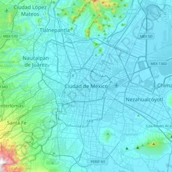
Navn: Topografisk kort Mexico City, højde, relief.
Sted: Mexico City, Cuauhtémoc, Mexico City, 06060, Mexico (19.27260 -99.29334 19.59260 -98.97334)
Gjennomsnittlig høyde: 2 321 m
Minste høyde: 2 223 m
Maksimal høyde: 3 508 m
Gi en donasjon
Andre topografiske kart
Klikk på et kart for å se dets topografi, dets høyde og dets relieff.
Gi en donasjon
Gi en donasjon
Álvaro Obregón
Mexico > Mexico City > Mexico City
Álvaro Obregón (Spanish pronunciation: [ˈalβaɾo oβɾeˈɣon]) is a borough (demarcación territorial) in Mexico City. It contains a large portion of the south-west part of Mexico City. It had a 2020 census population of 759,137 inhabitants and lies at an elevation of 2,319 m. above sea level.
Gjennomsnittlig høyde: 2 457 m
Gi en donasjon