
Gi en donasjon
Topografisk kart Mangaluru
Klikk på kartet for å vise høyde.
Gi en donasjon
Mangaluru
Mangalore is also the administrative headquarters of the Dakshina Kannada district; it is a commercial, industrial, educational, healthcare, and startup hub. The city's international airport is the second-largest and second-busiest airport in Karnataka. Mangalore City Corporation is responsible for the civic administration which manages the 60 wards of the city. Its landscape is characterised by rolling hills, coconut palms, rivers, and hard laterite soil. India's first 3D planetarium with 8K resolution display is located in the city. Mangalore is included as one of the cities in the Smart Cities Mission list and is among the 100 smart cities to be developed in India. It has an average elevation of 22 m (72 ft) above mean sea level. It has a tropical monsoon climate and is under the influence of the southwest monsoon. In 2017, Mangalore was ranked the 48th best city in the world to live in by a US survey, and the only Indian city in the top 50. It has its own International Airport which is around 15 km from the city.
Gi en donasjon
Om dette kartet
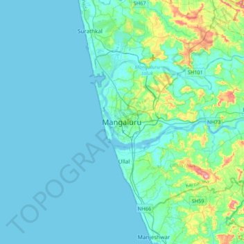
Navn: Topografisk kort Mangaluru, højde, relief.
Gjennomsnittlig høyde: 25 m
Minste høyde: -2 m
Maksimal høyde: 205 m
Gi en donasjon
Andre topografiske kart
Klikk på et kart for å se dets topografi, dets høyde og dets relieff.