
Gi en donasjon
Topografisk kart Canida Peak
Klikk på kartet for å vise høyde.
Gi en donasjon
Om dette kartet
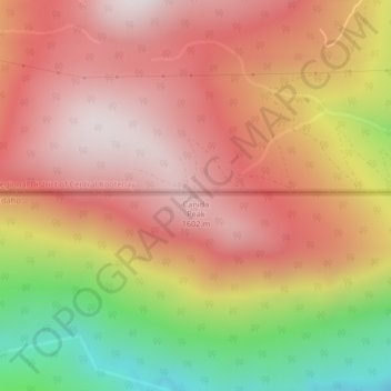
Navn: Topografisk kort Canida Peak, højde, relief.
Sted: Canida Peak, Boundary County, Idaho, United States (48.99962 -116.65027 48.99972 -116.65017)
Gjennomsnittlig høyde: 1 345 m
Minste høyde: 814 m
Maksimal høyde: 1 676 m
Gi en donasjon
Andre topografiske kart
Klikk på et kart for å se dets topografi, dets høyde og dets relieff.
Bonners Ferry
United States > Idaho > Boundary County
Bonners Ferry is located 27 miles (43.5 km) south of the Canada-United States border at 48°41′32″N 116°19′3″W / 48.69222°N 116.31750°W / 48.69222; -116.31750 (48.692110, −116.317626), at an altitude of 1,896 feet (578 m). According to the United States Census Bureau, the city has a total…
Gjennomsnittlig høyde: 584 m
Farnham Forest Research Natural Area
United States > Idaho > Boundary County
Gjennomsnittlig høyde: 745 m
Gi en donasjon
Bonners Ferry
United States > Idaho > Boundary County
Bonners Ferry is located 27 miles (43.5 km) south of the Canada-United States border at 48°41′32″N 116°19′3″W / 48.69222°N 116.31750°W / 48.69222; -116.31750 (48.692110, −116.317626), at an altitude of 1,896 feet (578 m). According to the United States Census Bureau, the city has a total…
Gjennomsnittlig høyde: 584 m