
Takk for at du støtter denne siden ❤️
Gi en donasjon
Gi en donasjon
Topografisk kart Boulder
Klikk på kartet for å vise høyde.
Takk for at du støtter denne siden ❤️
Gi en donasjon
Gi en donasjon
Boulder
Boulder is located at the base of the foothills of the Rocky Mountains, at an elevation of 5,430 feet (1,655 m) above sea level. Boulder is 25 miles (40 km) northwest of the Colorado state capital of Denver. It is home of the main campus of the University of Colorado, the state's largest university.
Takk for at du støtter denne siden ❤️
Gi en donasjon
Gi en donasjon
Om dette kartet
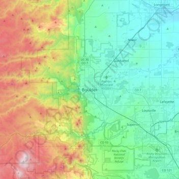
Navn: Topografisk kort Boulder, højde, relief.
Sted: Boulder, Boulder County, Colorado, 80306, United States (39.85499 -105.43055 40.17499 -105.11055)
Gjennomsnittlig høyde: 1 977 m
Minste høyde: 1 495 m
Maksimal høyde: 3 187 m
Takk for at du støtter denne siden ❤️
Gi en donasjon
Gi en donasjon