
Gi en donasjon
Topografisk kart Port Arthur
Klikk på kartet for å vise høyde.
Gi en donasjon
Port Arthur
Port Arthur sits in a low-lying coastal area of the Gulf Coast, characterized by its flat, marshy terrain. The city is located at an average elevation of just 8 feet (2 meters) above sea level, with parts of the surrounding region even closer to sea level. Its topography is dominated by wetlands, tidal marshes, and the estuaries of Sabine Lake and the Neches River, with vast stretches of flat, low-lying land interspersed by canals and small bayous. This terrain makes the area particularly susceptible to flooding, especially during storm surges from hurricanes or heavy rainfall. The region is also known for its proximity to the Gulf of Mexico, influencing its coastal landscape with sandy stretches and the presence of islands like Pleasure Island.
Gi en donasjon
Om dette kartet
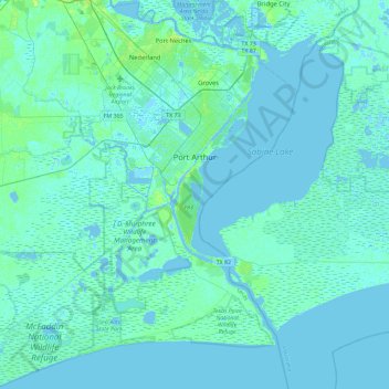
Navn: Topografisk kort Port Arthur, højde, relief.
Sted: Port Arthur, Jefferson County, Texas, United States (29.63312 -94.10660 30.03235 -93.81135)
Gjennomsnittlig høyde: 2 m
Minste høyde: -5 m
Maksimal høyde: 14 m
Gi en donasjon
Andre topografiske kart
Klikk på et kart for å se dets topografi, dets høyde og dets relieff.