
Gi en donasjon
Topografisk kart Watson
Klikk på kartet for å vise høyde.
Gi en donasjon
Om dette kartet
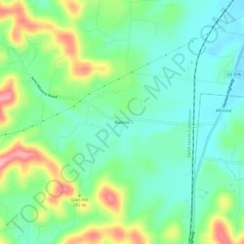
Navn: Topografisk kort Watson, højde, relief.
Sted: Watson, Williamson County, Tennessee, 37046, United States (35.73284 -86.73250 35.77284 -86.69250)
Gjennomsnittlig høyde: 270 m
Minste høyde: 226 m
Maksimal høyde: 363 m
Gi en donasjon
Andre topografiske kart
Klikk på et kart for å se dets topografi, dets høyde og dets relieff.
Fairview
United States > Tennessee > Williamson County
Fairview was incorporated on July 28, 1959, under the Uniform City Manager-Commission Charter as set out in the Tennessee Code Annotated. Fairview city limits are located about one mile (1.6 km) southwest from the Nashville-Davidson County line and has two interstates passing through it (I-40 & I-840). With an…
Gjennomsnittlig høyde: 233 m
Gi en donasjon
Carrington Hills Pond
United States > Tennessee > Williamson County > Franklin
Gjennomsnittlig høyde: 224 m
Gi en donasjon
Fairview
United States > Tennessee > Williamson County
Fairview was incorporated on July 28, 1959, under the Uniform City Manager-Commission Charter as set out in the Tennessee Code Annotated. Fairview city limits are located about one mile (1.6 km) southwest from the Nashville-Davidson County line and has two interstates passing through it (I-40 & I-840). With an…
Gjennomsnittlig høyde: 233 m