
Gi en donasjon
Topografisk kart North View
Klikk på kartet for å vise høyde.
Gi en donasjon
Om dette kartet
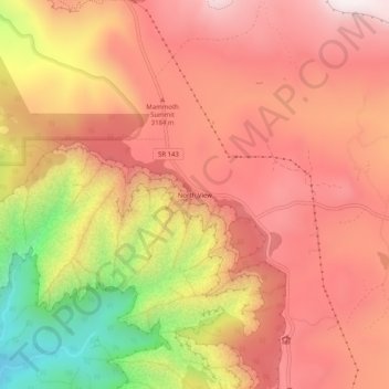
Navn: Topografisk kort North View, højde, relief.
Sted: North View, Iron County, Utah, 84719, United States (37.63683 -112.85406 37.67683 -112.81406)
Gjennomsnittlig høyde: 3 072 m
Minste høyde: 2 527 m
Maksimal høyde: 3 384 m
Gi en donasjon
Andre topografiske kart
Klikk på et kart for å se dets topografi, dets høyde og dets relieff.
Cedar City
United States > Utah > Iron County
Cedar City is located in the southeast Great Basin and is approximately 20 miles (32 km) north of the northeastern edge of the Mojave Desert. Its elevation of 5,846 feet (1,782 m) gives it a somewhat cooler climate compared to the nearby St. George region, though it retains cultural ties to the city —for…
Gjennomsnittlig høyde: 1 975 m
Brian Head
United States > Utah > Iron County
The community, at an elevation of 9,800 feet (3,000 m) above sea level, is the highest town in Utah. It is located on State Route 143 and is east of Interstate 15. Brian Head is approximately three miles north of Cedar Breaks National Monument.
Gjennomsnittlig høyde: 3 031 m
Cedar City
United States > Utah > Iron County
Cedar City is located in the southeast Great Basin and is approximately 20 miles (32 km) north of the northeastern edge of the Mojave Desert. Its elevation of 5,846 feet (1,782 m) gives it a somewhat cooler climate compared to the nearby St. George region, though it retains cultural ties to the city —for…
Gjennomsnittlig høyde: 1 975 m
Gi en donasjon
Cedar City
United States > Utah > Iron County
Cedar City is located in the southeast Great Basin and is approximately 20 miles (32 km) north of the northeastern edge of the Mojave Desert. Its elevation of 5,846 feet (1,782 m) gives it a somewhat cooler climate compared to the nearby St. George region, though it retains cultural ties to the city. For…
Gjennomsnittlig høyde: 1 975 m
Cedar City
United States > Utah > Iron County
Cedar City is located in the southeast Great Basin and is approximately 20 miles (32 km) north of the northeastern edge of the Mojave Desert. Its elevation of 5,846 feet (1,782 m) gives it a somewhat cooler climate compared to the nearby St. George region, though it retains cultural ties to the city —for…
Gjennomsnittlig høyde: 1 975 m
Cedar City
United States > Utah > Iron County
Cedar City is located in the southeast Great Basin and is approximately 20 miles (32 km) north of the northeastern edge of the Mojave Desert. Its elevation of 5,846 feet (1,782 m) gives it a somewhat cooler climate compared to the nearby St. George region, though it retains cultural ties to the city. For…
Gjennomsnittlig høyde: 1 975 m
Ashdown Gorge Wilderness
United States > Utah > Iron County
The wilderness is within the Dixie National Forest adjacent to Cedar Breaks National Monument and characterized by extremely steep-walled canyons cut through the west rim of the Markagunt Plateau. Elevations in the wilderness range from 10,500 feet (3,200 m) to 7,500 feet (2,300 m). Rattlesnake Creek and…
Gjennomsnittlig høyde: 2 715 m
Gi en donasjon
Brian Head
United States > Utah > Iron County > Brian Head
The community, at an elevation of 9,800 feet (3,000 m) above sea level, is the highest town in Utah. It is located on State Route 143 and is east of Interstate 15. Brian Head is approximately three miles north of Cedar Breaks National Monument.
Gjennomsnittlig høyde: 3 031 m